
Downloads and Support
Access comprehensive resources and support for all your water modelling needs
DHI provides a complete range of online resources, technical support, and training opportunities to assist you at every stage of your journey. Whether you're just starting out, or looking to maintain your expertise, we're committed to supporting you every step of the way.
Explore our customer care and training portals for a wealth of resources. The DHI Customer Care Portal provides centralised access to a wide array of online resources, including a full download center, product documentation, FAQs, video tutorials, and user forums. Meanwhile, our Training Portal offers various learning formats tailored to your schedule and learning style. Whether you prefer a quick webinar to learn new techniques or a comprehensive instructor-led course, you'll find the resources you need to succeed.
Lastly, don't miss our repository of new features and enhancements introduced in our latest annual releases and updates.
Portal-based support and training resources
New features and enhancements
Explore the latest innovations designed to increase productivity, accuracy, and value.
Urban: MIKE+ Model Manager, MIKE+ 2D Overland, MIKE+ Collection System, MIKE+ Water Distribution, MIKE Water Net Advisor
MIKE+ Model Manager
Enhanced Results Document Window:
Streamlined selection of locations for drawing time series or creating result tables with a more intuitive interface.
Separate windows for each result type, making it easier to manage and view specific data.
Additional filters and direct location selection simplify the process of finding and displaying relevant data.
A consolidated list structure helps users easily navigate and select locations for results, improving workflow efficiency.
New Scatter Plot Window:
Analyse the relationship between any two result items or locations with the new scatter plot feature. Users can easily explore correlations, such as how water level changes in response to discharge at a selected location.
New Plots Manager:
Save and organise all result windows in a tree structure with folder support for better management. Reopen saved result windows without needing to redefine settings, saving time and effort when re-analysing data.
Duplicate and Edit Plots:
Quickly duplicate and edit plots to reuse them with results from alternative scenarios, streamlining comparison and scenario analysis.
MIKE+ 2D Overland
Export isolines to shape files:
Seamlessly export isolines from MIKE+ to shape files for external use in other map-based software.
Streamlined scenario management:
Simplify the combination of different 2D data and boundary configurations for scenario creation. Easily create alternative scenarios for 2D boundary data, such as climate change assumptions.
Combine 2D boundary data with alternative settings like protection dikes for comprehensive scenario analysis.
New ‘Hazard tool’:
Quantify flood hazard based on 2D flooding results for accurate hazard assessments. Perform post-processing on 2D flooding results to quantify and analyse flood hazards efficiently.
New 'Discharge calculation' tool:
Estimate total discharge through user-defined sections based on 2D flow results. Perform post-processing of 2D flow results to calculate total discharge efficiently for flood analysis.
MIKE+ Collection Systems
Couple soakaway nodes to MIKE SHE:
MIKE+ now supports coupling soakaways, in addition to pipes and manholes, with MIKE SHE for groundwater interaction simulations.
Soakaways, modelled as infiltration basins in MIKE+, can now be linked to MIKE SHE for comprehensive interaction between surface water and groundwater.
Provides better representation of collection system networks interacting with groundwater, especially for projects involving soakaways.
Enhanced simulation results:
New output options now include "spilling discharge" for manholes in MIKE 1D simulations.
Track and quantify spilling discharge from manholes for a more comprehensive evaluation of urban drainage systems.
MIKE+ Water Distribution
Q-H results plotting for pumps:
Analyse pump performance by plotting flow (Q) versus head (H) to assess operational efficiency.
Helps users evaluate pump operation ranges, ensuring optimal flow and pressure for efficient energy use.
Provides insights into pump performance, aiding in the selection of the correct pump capacity for water distribution networks.
Check the operational ranges of pumps to fine-tune system performance and enhance water distribution management.
Addition of 'Modified Hazen-Williams' head loss type:
Introduced as an alternative head loss calculation method.
Offers more flexibility by providing an additional head loss calculation method alongside the more precise methods already available in MIKE+.
Modelling pressure and flow control valves under hydraulic transient conditions:
Pressure and flow control valves can now be simulated under hydraulic transient (water hammer) conditions.
Valves automatically adjust their stroke position to maintain the required pressure or flow set point during transient events.
Simulate pressure reducing valves, back pressure control valves, and flow control valves under dynamic hydraulic conditions.
MIKE Water Net Advisor
Enhanced User Interface with React Web:
The interface has been updated using Microsoft React Web technology, providing a more modern and responsive user experience.
Variable Speed Pump Editing:
Common editing features have been expanded to include variable speed pump settings, providing more control over pump operations.
Increased User Security and Password Settings:
Passwords now need to comply with updated security standards, including minimum length, the inclusion of special characters, and the requirement for expiration and renewal dates.
System Layers:
The system layers have been updated to incorporate carbon emissions and average water demand, offering a more comprehensive view for analysis.
Online Zones and NRW Indicators:
The online zones feature has been updated to incorporate leakage metrics such as night flow minimum, infrastructure leakage index, unavoidable and actual water losses.
Network Junction Zones:
The model layers have been updated to include network junction zones, enhancing the ability to analyse and manage network connections within the system.
Inland: FEFLOW, MIKE SHE
FEFLOW
New Implicit Modelling Workflow:
• Construct geologically meaningful surfaces.
• Effortlessly generate structural models automatically from boreholes and stratigraphic data.
• Leverage a streamlined toolbar for borehole digitisation, importing/exporting, and data overview functionalities. Watch Video
Map Projections and Online Visualisation:
• Set a reference projection for FEM models or Supermesh, enabling coordinate-aware mapping.
• Enjoy on-the-fly reprojection for seamless alignment between project and map file coordinates.
• Choose from multiple styles of "Online Background Maps" to enhance model visualisation and presentation. Watch Video
Extended Equation of State (EOS):
• Determine whether a problem remains in the liquid phase or involves multiphase conditions with the new "Temperature Relative to Boiling" parameter.
• The expanded EOS section now better supports deep geothermal modelling cases with temperatures up to 350 °C and fluid pressures up to 100 MPa.
• Implement non-linear density changes depending on temperature, concentration and pressure. Watch Video
Surface Water and Groundwater Coupling:
• Analyse river networks and their interaction with surrounding groundwater systems by coupling FEFLOW with MIKE 1D.
MIKE SHE
Extended Collection System Coupling in MIKE SHE
• Users can now simulate soakaway drainage directly within MIKE SHE by coupling MIKE 1D collection system models.
• Route water from soakaway features into groundwater models for more integrated analyses.
• Assess the impact of rising groundwater levels on soakaway performance with improved accuracy and flexibility.
Single MIKE 1D Setup for Rivers and Collection Systems
• Couple rivers and collection systems in a single MIKE 1D setup, eliminating the need for separate models.
• Seamlessly exchange data between rivers and collection systems without previous limitations.
• Simplify model workflows by integrating both systems in one unified MIKE 1D model.
Marine: MIKE 21/3 - MIKE 21 Wave Model FM, MIKE 3 Wave Model FM, Sand Transport Mud Transport, MIKE Eco Lab, Sand Transport, LITPACK, MIKE ZERO
MIKE 21
Ability to save 2D structured overlays as .dfsu output files in all modules
• 2D structured overlays can now be saved as .dfsu output files in all MIKE FM modules (HD, TR, ST, MT, EL, PT).
• Enables the use of all FM-based tools on gridded datasets.
MIKE 21 Wave Model FM
Introducing MIKE 21 Wave Model FM
DHI’s first unstructured Boussinesq-type wave model based on a cell-centered finite volume scheme.
MIKE 21 Wave Model FM offers significant improvements over MIKE 21 Boussinesq Waves:
• A simple switch transforms a 3D wave model to a 2D wave model for testing or screening purposes.
• Improved workflows for internal wave generation, setup of porosity and sponge layers (no need to run separate tools to precompute input data).
• Improved flooding and drying for overtopping of breakwaters.
• New porosity formulation for improved accuracy.
• Standard FM features are available, for example, inclusion of coastal vegetation.
• Fully unstructured triangular meshing for exact boundary fitting to quay walls, breakwaters, groynes, and other structures.
• Local mesh refinement to reduce the number of elements with no loss of accuracy.
• OpenMP and MPI parallelisation with an official Linux version for HPC systems.
• Includes inundation output for coastal flood mapping.
• Post-processing with Data Extraction FM and standard FM viewers.
MIKE 21 Wave Model FM is currently available with valid SMA on MIKE 21 Boussinesq Waves or an appropriate subscription. It can also be purchased (classic BW included) via subscription or perpetual license.
MIKE 21 Sand Transport
Improved sand transport calculations with helical flow
• Enhanced flux calculations from 2D flow fields improve sand transport accuracy.
• May result in output differences compared to Release 2024.
MIKE 3
Output of horizontal plane for field type '3D' in MIKE FM modelling system
• The MIKE FM modelling system now supports the output of horizontal planes for the field type ‘3D’ across all modules, including HD, TR, ST, MT, EL, and PT.
Performance improvements in MIKE 3 Wave Model FM and MIKE 3 Flow Model FM
• The performance of MIKE 3 Wave Model FM and the non-hydrostatic version of MIKE 3 Flow Model FM (based on the Navier-Stokes equations) has been enhanced.
• These improvements are primarily related to the linear equation solver, resulting in significant benefits for larger model setups.
Ability to save 2D and 3D structured overlays as .dfsu output files in all modules
• Both 2D and 3D structured overlays can now be saved as .dfsu output files in all MIKE FM modules (HD, TR, ST, MT, EL, PT).
• Enables the use of all FM-based tools on gridded datasets.
MIKE 3 Wave Model FM
Added inundation output
• Inundation output is now available in MIKE 3 Wave Model FM.
MIKE 3 Mud Transport
Vessel propeller wash-induced mud resuspension in the Mud Transport module
• Analyse the impact of vessel propeller wash on seabed mud resuspension to gain insights into sediment dynamics in high-traffic marine areas.
• Nearfield model: Embedded sub-model for analytical/integrated jet flow and bed impact.
• Farfield model: MIKE 3 FM Hydrodynamic and Mud Transport integration.
• Fully decoupled option for a new, faster solution.
MIKE 21 and MIKE 3
Culvert improvements in MIKE 21 Flow Model FM and MIKE 3 Flow Model FM
• Updated QH-relation table calculations for better alignment with MIKE 1D
Improved data handling within MIKE Zero
• Dialogs, lists, and tables in MIKE Zero have been made larger or resizable for a smoother user experience (for example, point series locations in the Output Specification page).
Extended wind forcing options in the Hydrodynamic module
• Wind speed, direction and components can now be specified in all three relevant formats to better align with MIKE 21 Spectral Waves FM.
• For 2D time-varying wind maps, users can choose whether to include the effect of pressure.
MIKE ECO Lab
First release of MIKE ECO Lab 2.0
• MIKE ECO Lab is now available in "Classic" or "Version 2.0" modes.
• Version 2.0 features a complete rewrite of the engine core, including:
- Thread-safe memory handling
- Enhanced integration solver
- Improved plug-in API
• The new engine now supports parallelisation (OpenMP) for simultaneous calculations of multiple nodes and particles.
• The settling and buoyancy scheme has been improved to significantly reduce mass balance issues.
• Feature updates and further development will be exclusive to MIKE ECO Lab Version 2.0.
Sand Transport and Mud Transport module
Improved performance in sediment transport rate calculations using sediment transport tables
• Sand Transport module calculations are approximately 2x faster.
• Mud Transport module calculations are approximately 3x faster.
LITPACK
Improved interpolation between cross-shore profiles
• New option to specify profile locations along the coastline by origin (from list).
• Enhances calculation of coastline evolution using a linear interpolation of wave and current forcings between profiles.
More interactive workflows in the Littoral Processes FM editor
• Enhanced interactivity in workflows, allowing direct definition of locations on the map.
Improved handling of differing map projections
• The Littoral Processes FM UI now offers enhanced handling of differing map projections.
• This improvement applies to the display of coastlines, baselines and sections.
Enhanced robustness in shingle-sized sediment calculations
• Improved accuracy of transport calculations for shingle-sized sediment in the Littoral Drift model.
MIKE Zero (MIKE 21 and MIKE 3)
MIKE Zero Toolbox: Two new tools have been added to the Statistics Group
• DFSU Vertical Statistics: This new tool replaces the hidden DataVerticalAveragingFM.exe, supporting maximum, minimum and mean calculations. Some non-essential functions were removed, so it is not fully backward compatible.
• DFSU Statistics: A new tool that merges the functionality of DataStatisticsFM.exe and DataExceedanceFM.exe. It supports maximum, minimum, mean, standard deviation, exceedance and percentile calculations. The percentile feature is new, and the tool is not backward compatible for exceedance calculations.
• Note: The hidden tool DataExceedanceFM.exe will be removed in MIKE Zero 2025.
Data Viewer: Miscellaneous enhancements
• Reproject mesh files directly within Data Viewer
• Save and load polygon selection areas to simplify manual post-processing
• View area of selected elements within a polygon for more efficient post-processing
• Save and load time series point locations, with additional visual improvements
• Improved visualisation of transects
Data Viewer and Plot Composer: Resizable properties dialogs
• The Properties dialogs for Time Series Plot and Profile Plot are now resizable
• Additional improvements to the properties tables:
- Tool tips display full field information (e.g., file name and path)
- Double-click a header to resize the column
- Double-click the index field to resize all columns
Mesh Manager: Local refinement enhancement
• Local refinement can now be specified based on the size of the element area in the Mesh Manager tool.
Graphical Overview tab: Enhancements
• Gate control points are now visible.
• Supports Littoral Processes FM (LITPACK) models.
Results Reviewer: New split view comparison
• You can now compare two files side-by-side in the Results Viewer using the slider-based 'Split View Compare Files' function.
New configuration option for MIKE Cloud simulations
• Configure the maximum duration without engine progress before automatically canceling a MIKE Cloud simulation.
Updated Engineering Unit Management (EUM) system
• Now includes parameters for water chemistry, carbon emissions and pollutant loads.
Data Extraction FM Tool: Significant enhancements
- Improved performance with OpenMP parallelisation
- Input data file view option
- Input data file validation
- Aligned output file selection with MIKE 21/3 input editors
- Bathymetry display in Geographical View
- Ability to save 2D and 3D structured overlays as DFSU files in all modules (HD, TR, ST, MT, EL, PT)
- Horizontal plane output for '3D' field type in all modules (HD, TR, ST, MT, EL, PT)
Integrated platforms: MIKE+
MIKE+ Model Manager
Results viewing usability improvements across MIKE+
- Load 1D result files with different networks, remembering selections for loading and plotting results.
- Keep the 'TS from map' window active after opening a TS plot, allowing location selection even without a result layer.
- Add a 'Symbolic' mode in the Profile plot.
- Enhance zooming within time series plots with synchronized zoom options and a bookmark manager for saving zoom windows.
- Improve zooming options in TS plots for enhanced precision.

Python scripting with MIKE+Py
-
New access to custom scripting tools to read and edit the MIKE+ database and tools.
-
New customisation and automation features, granting users direct access to the MIKE+ database for seamless data retrieval and editing, complete with automatic updating of related tables.
Additional results obtained from Water Hammer simulations
-
Additional detailed results on airflow for air valves.
-
Additional detailed results on the volume of water, air, and water depth for air chambers.
New Q-H plot for fire flow analyses
-
New plot/chart, the 'Q-H' table, for analysing relationships between 'Hydrant flow' and 'Residual pressure' from fire flow simulations.
-
Ability to superimpose multiple plots and zoom in for detailed examination and visual representations.

Read the MIKE+ Release Notes
Urban: WEST
WEST
Extension of ASM2dMod with nitrous oxide (N2O) producing pathways
-
Integrate nitrous oxide (N₂O) production into your models.
-
Assess N₂O production from both autotrophic ammonium-oxidizing and heterotrophic denitrifying microorganisms (NDHA Model).
-
Supports more accurate determination of CO₂ footprint and identification of N₂O mitigation strategies.
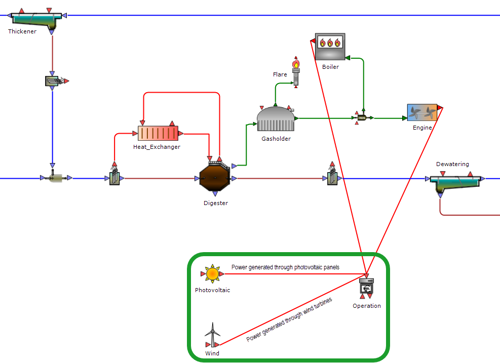
Simple photovoltaic and wind energy production models added
-
Integrate models for estimating energy production from photovoltaic panels and wind turbines using local conditions and geometry.
-
Enhance cost calculations with energy production variables from new renewable sources for comprehensive energy balancing.
-
Enable more accurate financial modelling and sustainability assessment within the plant-wide cost model.
Addition of a User Project branch to the Getting Started pane
-
Access 'User Projects"' in the Getting Started pane, enabling you to add and manage projects from various locations on your devices.
-
New shortcuts to 'User Projects' alongside 'Recently Used' and 'WEST Projects' for quick and easy navigation.
-
Enhance the visibility of key properties and settings for each project within 'User Projects' for straightforward identification and access.
New sample project to demonstrate the updated influent fractionator (for ASM2dMod) (watch the video)
-
Access the new sample project demonstrating the updated Influent Fractionator tool for ASM2dMod, enhancing WWTP model setup.
-
Improve simulation accuracy with the updated Influent Fractionator using dynamic regression to convert diverse time series measurements into model components.
-
Improve flexibility and applicability of the WWTP modelling process with updated measurements on varying time schedules.
New point-settler mode for primary clarifier
- New point-settler mode for the primary clarifier allows for separate efficiency settings for each particulate component.
- Customise solid removal efficiencies by particulate species, enhancing treatment accuracy and flexibility.
- Facilitates more detailed and tailored process modelling within wastewater treatment simulations.
SRT-based controller for wastage of excess sludge (WAS) (watch the video)
- Use the new SRT-based controller for excess sludge wastage, integrating a PID controller with anti-windup features.
- Maintain desired sludge age in activated sludge systems by regulating sludge wastage.
- Enhance operational precision and stability in wastewater treatment processes.
Read the WEST Release Notes
Inland: FEFLOW, MIKE SHE
FEFLOW
Enhanced 3D Supermesh Preprocessing Panel (watch the video)
- Advanced Surface Repair and Remesh capabilities: Now powered by the robust Geode-FEFLOW implementation.
- Support for complex geometries: Capable of repairing highly intricate 3D datasets.
- Geode FEFLOW Tools for dataset correction: Ensure smooth transitions and accuracy in groundwater models through precise corrections of any inconsistencies.
Enhanced 3D Volumetric Mesh Generator by Geode (watch the video)
- Users can now impose local refinements more precisely using edge-sizes on Supermesh elements like points, polylines, surfaces, and regions.
- Model inclined boreholes and complex fault systems with high accuracy and performance.
Introducing the FEFLOW Engine Subscription
- Includes FEFLOW FMH3, piChem, piFreeze, and piMIKE1D.
- Supports concurrent FMH3 simulations utilising all available CPU-cores.
- Offers all modelling components at a reduced price.
- Enables model calibration and uncertainty analysis through FePEST and MIKE Cloud Execution.
- View more details on the new FEFLOW Engine subscription
Read the FEFLOW Release Notes
MIKE SHE
Workflow improvements
-
Users can now save vertical profiles within the Results Viewer and preview these profiles before making a selection.
-
Modify the size ratio between the Detailed Water Movement time series plots and the map overview with the new slider functionality.
-
Gain control over the y-axis range of Detailed Water Movement time series plots, with options to normalize the y-axis across all plots, facilitating easier model result comparison and improved accuracy in model calibration, validation, and reporting.
Collection system coupling improvements
-
Seamlessly integrate MIKE SHE with a MIKE+ collection system model, introduced in the 2024 release.
-
Improved time step synchronisation enables users to compute exchanges at the MIKE SHE overland time step, better matching the MIKE+ model's timing.
-
Enhanced simulation accuracy to boost consistency and reduce water balance errors between simulations.
-
Increased analytical flexibility allows for more precise assessments of collection system leakage impacts on groundwater.
Water quality simulation improvements
- Run water quality simulations without activating the overland flow module.
- Avoid the computationally intensive overland flow module to decrease simulation times effectively.
- Ideal for scenarios where surface flows do not significantly impact groundwater quality, enhancing efficiency and focus.
Read the MIKE SHE Release Notes
Integrated platforms: MIKE+
MIKE+ Model Manager
Display BIM (Building Information Modeling) data on map view
- Enhance asset management, from planning to operations
- Potential applications in urban network management
- To learn more, see Types of external layers that can be added to a map
Redesigned profile plots
- Data displayed in table format for improved readability
- User control over row order, fonts, colors, and text direction
- Export profile plot data to text files for Rivers and Collection system models, in addition to Water Distribution models
- To learn more, see Export to text file and Profile plot tools
Enhanced Versions Management Tool
- Improved database comparison performance.
- Added data filtering for focused and efficient comparisons.
- To learn more, see Compare tool
Introducing Python Scripting library for MIKE+ models and database
- Enables reading and writing SQLite database
- Provides tools like import, topology repair, interpolation, and connection repair
- Supports MIKE IO and MIKE IO 1D
- Easily accessible via ‘pip’
MIKE+ Collection Systems
New tool for creating elevation zones
- Designed for Rainfall-runoff models with the RDI method and snow melt considerations
- Automatically splits catchment into specified elevation zones using DEM data
- To learn more, see Create elevation zones from DEM tool
Extension of the land use method for catchments
- Catchment processing now derives the fractions of a catchment covered by background polygon layers and assigns land uses accordingly.
- When using RDI, the land use table in the catchment editor accepts RDI parameter sets as input too.
- To learn more, see Model setup and Land use layers
Integrate seasonal groundwater data from MIKE SHE for inflow and infiltration analysis
- Improve understanding of seasonal groundwater dynamics
- Make informed decisions for sustainable and resilient infrastructure operations
- To learn more, see Flooding
New Zone Water Balance feature
- Calculate water balance for defined zones with measured time series (See Water balance)
- New ‘Compute zone demand and leakage’ tool estimates average demand and leakage (See Compute zone demand and leakage tool)
- ‘Distributed demands’ tool populates demands in nodes or pipes for simulations
- ‘Create time patterns’ generates daily or weekly demand patterns based on measured data, saving time on manual tasks. (See Create time patterns tool)
Introducing VSD pump control based on link flow
- Complements existing pressure and water level control types
- Set control point as constant or time variable
- To learn more, see Control type
MIKE+ 2D Overland
New Create Flood Maps tool
- Transforms raw flood result files into classified result polygons
- Works with various result types, including flood hazard and current speed
- Includes filters to simplify the map, saving users time compared to manual GIS processing.
- To learn more, see Create flood maps tool
Direct TIFF file support for 2D interpolation
- Eliminates the need to convert TIFF files to dfs2 format for elevation assignment to 2D meshes.
Read the MIKE+ Release Notes
Urban: MIKE WaterNet Advisor, WEST
Automatic reporting of system performance indicators in the hydraulic engine
- Includes metrics like average pressure, natural input energy, pump power energy, energy delivered to users, energy dissipated, shaft energy per volume, excess of supplied energy, network efficiency, and standard energy compliance.
Redesigned WD online module
- Direct compatibility with MIKE+ model database in SQLite format
- Improved performance
- Seamless integration of online models with standard (offline) models in MIKE+
- No data conversion or loss when opening online models in MIKE+
WEST
Enhance your activated sludge management for optimal performance (watch the video)
- Seamlessly take tanks offline for maintenance or dynamic conditions
- Sequentially empty and fill tanks for precision and workflow optimisation
- Ensure numerical stability and accurate results
- Try our demo project to master activated sludge management
Boost your evaporation modelling capabilities with Penman-Monteith precision (watch the video)
- Utilise the Penman-Monteith evaporation model in IUWS (1, 2, and 3) instances
- Based on the UN FAO equation for potential evapotranspiration (ETo)
- Ensures higher accuracy in simulations
Recommended for ETo calculations - Try our demo project to master this powerful tool.
Categorise and manage simulation runs with new folder options (watch the video)
- Easily organise runs in separate folders when saving or loading snapshots
- Receive compatibility notifications when browsing folders
- Save multiple sets of results per project for greater flexibility and comparison.
New integrated library for micropollutants (watch the video)
- Simulate the occurrence and fate of micropollutants, such as pharmaceuticals, from catchments to wastewater treatment plants
- Model micropollutant discharges from households and industries
- Predict micropollutant fate and removal in various treatment processes
- Determine preferential removal mechanisms
- Try out demo project to further explore this new library
Read the WEST Release Notes
Inland: FEFLOW, MIKE SHE
FEFLOW
Enhanced Well Manager Editor (watch the video)
- Group diverse well types, be it water or geothermal
- Test and apply rules to well groups
- Handle the wells within groups and apply rules
Geothermal extension in Well Manager (watch the video)
- Working on low enthalpy geothermal? Use the Geothermal extension of the Well Manager for creating open-loop and closed-loop systems
- The ‘Closed-Loop’ rule enables rapid interconnection of 100+ BHEs with unparalleled ease
New Well Manager rules (watch the video)
- ‘Inactive Wells’ rule enables hassle-free deactivation while retaining data integrity
- ‘Shared Properties’ rule simplifys property changes across multiple wells to ensure consistency
- ‘Distributed Rate’ rule allocates rates equally among wells for optimal performance
Revamped Observation Point Dialogue and centralised user interface
- All model outputs needed for calibrate and valiate your work has been consolidated into one location
- Manage budget groups and effectively track flow rates in various contexts such as pits and rivers
- Content group management to track mineral mass within specified volumes
- Multiple reference curves enable more nuanced analysis and insights for your model
FEFLOW Python interface for Supermesh (watch the video)
- Generate 2D and 3D meshes using an extended Python interface
- Access mesh generators and interpolation methods directly from scripts
- Efficiently test and evaluate new conceptual models while allowing for variations in geometry and discretisation
New Cross-Section Generator within the Python Interface
- Extract 2D meshes from existing 3D models
- Simplify your workflows and enhance presentations and reports
New DXF/DWG format support
- Directly access and interpret DXF and DWG files within the application environment
- Bridge hydrogeological insights and CAD design data
New 3D editing tools in FEFLOW Supermeshes (watch the video)
- Create 3D domains from a single surface
- Achieve precise geometry editing with the new 3D snapping feature
- Easily repair or remesh Supermesh using FEFLOW Advanced
- New export feature eliminates the need to redo meshing.
- Decrease reliance on third-party software
Major Qt version upgrade
- Smoother graphical operations
- Enhanced system stability and reliability to reduce potential issues
Read the FEFLOW Release Notes
MIKE SHE
New water quality modelling option for floodplains
- Model water quality alongside floodplain inundation using flood codes
- Enable solute exchange between flood code cells, overland flow, and groundwater (saturated zone)
More accurately analyse inflow and infiltration by integrating seasonal groundwater data from MIKE SHE into MIKE+
- Gain a more comprehensive understanding of how seasonal groundwater dynamics impact your systems
- Make informed decisions to ensure sustainable and resilient infrastructure operations by considering seasonal variations in inflow and infiltration
Read the MIKE SHE Release Notes
Marine: MIKE 21, MIKE 3, and MIKE ECO Lab
MIKE 21 and MIKE 3
Enhanced hydrodynamic calculations in MIKE 21/3 Flow Models FM
- Improved stability of both higher-order and low-order schemes in areas of flooding and drying. This is particularly beneficial for three-dimensional simulations.
- Improved accuracy and stability of our fast low-order scheme where steep gradients are present. Resulting velocities along riverbanks and underwater channels now compare well with our more accurate higher-order scheme.
- Improved performance of GPU solvers for simulations including infrastructure features and flow-dependent bed resistance.
Improved advection-dispersion calculations
- Improved accuracy of advection-dispersion scheme with an upgraded discretisation of the diffusion terms.
MIKE ECO Lab
New and improved MIKE ECO Lab template creation workflows
- Create new templates from existing models using drag-and-drop functionality in the MIKE ECO Lab graphical user interface.
- Export model components to create a library of building blocks for new templates.
- Model complex feedback loops with new 3-way coupling of hydrodynamics and heat transport.
- Benefit from enhanced MIKE ECO Lab plug-in interface and extended Oil Spill templates on Linux.
Mud Transport module
Extended feature set and scientific enhancements
- Improved hotstart functionality using layer and fraction distribution as initial conditions.
- New options for erosion calculations including a new RMS shear stress formulation and specification of critical shear stress for each individual fraction.
- New spilling types for dredging simulations.
- New and improved outputs including extended output of mean velocity, bed distribution items, and three-dimensional bed parameters output.
- Substantial refactoring and modernisation for improved performance and accuracy.
Sand Transport and LITPACK
New sand transport and beach process functionality
- For two and three-dimensional sand transport calculations, an extended Engelund & Fredsøe bed load formula has been added to better consider slope effects.
- The Littoral Processes FM graphical user interface has been improved in respect of file selection, validation and viewing
Read the MIKE 21 and MIKE 3 Release Notes
General: MIKE OPERATIONS, MIKE Zero
MIKE OPERATIONS
Script Manager integration with GitHub
- Native support for GitHub scripts (editing, running, debugging)
- No need to import scripts to the database
- Reusable scripts across projects with version control
- Run GitHub scripts in Visual Studio Code, PyCharm, or Spyder
- Run CPython scripts with DHI Cloud Platform job service
- Schedule and execute CPython scripts from MIKE OPERATIONS Job Manager
- MIKE WORKBENCH upgraded to Python 3 for improved security and design
Temporal feature classes in GIS Manager
- Support for storing and visualising multiple time steps
- Store relevant model outputs efficiently (e.g., contours, time-varying flood contours)
- Reduced data storage requirements
- Option to avoid storing complete 2D results for each simulation
- Enhanced efficiency for web applications compared to using dfs2 and dfsu files for visualisation
FEFLOW adaptor improvements
- Support for multi-layer wells
- Contour line outputs
- Additional spatial outputs (concentration, well type, node selection, LCE, Slice number)
Read the MIKE OPERATIONS Release Notes
MIKE Zero
MIKE Zero workflow improvements
- MIKE Zero editors and viewers now include MapTiler’s online background maps to support model creation and results visualisation
- New Mesh Manager tool for mesh filtering and refinement
- New option to use GeoTIFF files in Mesh Generator
- Performance of the Frequency Response Calculator for MIKE 21 Mooring Analysis has been improved
- Enhanced isoline functionality allows users to export as Shape files and xyz files
- Copy spatial extents between Data Viewer pages with [Ctrl]+[Shift]+[C]/[V]
- More MIKE engines are now supported in MzLaunch
- Inundation output items now include Flux items
Integrated platforms: MIKE+
MIKE+ Model Manager
Save your results layout without needing to open a database
- View, analyse, save, and re-open your model results, all on a user-friendly platform
- Retain your model results’ presentation layout and symbology for future reference
MIKE+ Collection Systems
Create user-defined columns for more custom results analysis
- View model results alongside your input data within the same editors.
- Achieve optimal pipe network characteristics by adjusting them based on specific criteria in the results while simultaneously editing input data and viewing the results
- Eliminate the hassle of searching for matching data (e.g., pipes) between two separate tables, as previously required
Unleash the full potential of RDI hydrological modelling with advanced new options
- Explore snowmelt effects and irrigation impacts using elevation zones
- Enhance your understanding of river behavior and precipitation
New option to specify infiltration per land use
- Define multiple types of land uses in each catchment and customise loss/infiltration settings
- Model catchments with greater precision and accuracy
New option for rainfall interpolation from stations
- Experience more realistic and precise modelling results, as the new catchments modelling option offers interpolation in space for rainfall intensities from rain gauges
- Avoid abrupt changes in rainfall intensities between different zones
- Benefit from more gradual rainfall intensity distribution than the previous uniform values approach
MIKE+ Water Distribution
Improve accuracy using the new, fully optimised Water Distribution Autocalibration module (watch the video)
- Optimise your main model parameters for automatic calibration against measured data
- Find the best settings for pipe friction coefficients, locate closed isolating valves within the water distribution network, adjust water consumptions, and find point leakages.
- Achieve a better match between observed data and simulated model results
Manage your water distribution simple control logic all in one place
- Access all simple controls defined on your pipe networks via a comprehensive table
- Stay on top of simple controls across your entire pipe network, whether applied to pipes, pumps, or other elements, with a new, easy-to-use editor
Create user-defined columns for more custom results analysis
- View model results alongside your input data within the same editors.
- Achieve optimal pipe network characteristics by adjusting them based on specific criteria in the results while simultaneously editing input data and viewing the results
- Eliminate the hassle of searching for matching data (e.g., pipes) between two separate tables, as previously required
MIKE+ 2D Overland
New Cross-Section Tool designed for advanced 2D visualisation
- Draw a vertical cross-section view of your 2D data within the MIKE+ 2D Overland domain or other DEM.
- Verify the accuracy of your 2D domain file’s resolution to properly represent finer-scale topographical features like dikes.
- Gain a better understanding of topographical changes with the vertical view, which allows you to visualise changes in elevation more clearly than a standard map’s horizontal view.
Accelerate data processing with MIKE+’s enhanced GPU performance for 2D Overland
- Boost your data processing capabilities with MIKE+’s latest 2D Overland GPU improvements, which now enable the use of GPUs for infrastructures (buildings, roads) and Depth Average roughness calculations.
- Effortlessly handle large datasets and complex simulations with the power of GPU processing.
Boost your river management and restoration efforts with MIKE+’s advanced Sediment Transport module features (watch the video)
- Predict sediment dynamics in river systems for better river management and restoration efforts.
- Consider factors like sediment size, flow velocity, and channel bed slope to model a wide range of sediment transport processes.
- Simulate sediment movement, deposition, and erosion to assess the impact on river morphology, water quality, and aquatic habitats.
- Gain insight into the complex interplay between sediment and river ecosystems.
- Make informed decisions that enhance the health and sustainability of river systems.
View topographical changes along a river with external DEM cross-sections
- Compare the latest topographical information from a new DEM to the existing river model to ensure representation of the new topography.
- Get a comprehensive view of the river model and update it with new information if needed.
- Integrate new cross sections from external DEMs
- Update your river topography based on the latest data.
New option to set markers at intersections with polylines from a shape file
- Edit river cross sections and set markers using lines drawn on a map in any GIS product.
- Save these lines in a shape file to indicate the exact location of riverbanks and apply different roughness/friction properties in the river bed and flood plain.
- Use external data to inform your river cross- section markers
Unleash the full potential of RDI hydrological modelling with advanced new options
- Explore snowmelt effects and irrigation impacts using elevation zones
- Enhance your understanding of river behavior and precipitation
New option to specify infiltration per land use
- Define multiple types of land uses in each catchment and customise loss/infiltration settings
- Model catchments with greater precision and accuracy
New option for rainfall interpolation from stations
- Experience more realistic and precise modelling results, as the new catchments modelling option offers interpolation in space for rainfall intensities from rain gauges
- Avoid abrupt changes in rainfall intensities between different zones
- Benefit from more gradual rainfall intensity distribution than the previous uniform values approach
MIKE+ SWMM
Create user-defined columns for more custom results analysis
- View model results alongside your input data within the same editors.
- Achieve optimal pipe network characteristics by easily adjusting them based on specific criteria in the results while simultaneously editing input data and viewing the results.
- Eliminate the hassle of searching for matching data (e.g., pipes) between two separate tables, as previously required.
Inland: FEFLOW
New 3D Supermesh tools (watch the video)
- Create intricate 3D Supermeshes using a new set of interactive tools – 3D Point, 3D Polyline, 3D Plane, and 3D Bounding Box.
- Integrate geological faults into your 3D Supermeshes with the new 3D Supermesh Plane tool that puts elevation, depth, and inclination angle values at your fingertips.
- Define borehole traces directly from the FEFLOW GUI.
Improve your Supermesh projects with our latest update for 2D/3D modelling (watch the video)
- Add new 2D/3D geometries to your existing Supermesh projects with the new ‘Add Supermesh Elements’ dialog
- Convert multiple maps into Supermesh Elements with just a few clicks.
Streamline your modelling workflow with the new 3D Mesh Generator (watch the video)
- Save time with the extended FEFLOW Advanced module which now includes a new 3D Mesh Generator powered by Geode-Solutions.
- Access one single pipeline that covers 3D Supermesh repair, surface remesh, and 3D unstructured mesh.
- Mesh previously unmesheable geologies using TetGen.
Access the powerful Well Manager directly through the Python interface (watch the video)
- Create, edit, or delete any well configuration from Well BCs, Multilayer Wells, and Borehole Heat Exchangers.
- Use coordinates, snap distances, or 3D polylines directly from Python.
- Quickly update well properties or change well types with ease
General: MIKE OPERATIONS
MIKE OPERATIONS
Improve your workflow with the enhanced Script Manager which now supports CPython
- Reduce configuration time by taking advantage of the embedded common Python libraries in MIKE OPERATIONS.
- Easily integrate MIKE OPERATIONS APIs and logic into your own scripts with the help of code snippets for all components in the UI (data, tools, etc.), saving you time and effort in the configuration process.
- Boost script performance with extended APIs and new query tools.
Enhance decision-making by using your FEFLOW models in MIKE OPERATIONS
- Make the most out of the FEFLOW Adapter’s improved support of relevant FEFLOW features for Decision Support Systems.
- Improve your decision-making process in fields such as irrigation, mining, waste storage, and water quality.
Access global datasets instantly with MIKE OPERATIONS
- Automatically import common global datasets, including rainfall forecasts, into MIKE Cloud.
- With a valid MIKE Cloud account, users can easily access this data directly from MIKE OPERATIONS.
- Reduce costs and save time by eliminating the need to develop and maintain data import scripts, as all necessary data is now readily available.
Integrated platforms: MIKE+
MIKE+ Model Manager
Ability to promote Child to Base in the Scenario Manager
- Rely on a new option to more easily define your base scenario (i.e. default setup) from a set of alternative scenarios
- Avoid having to keep and maintain other alternatives in the model setup
Import and export improvements
- Automatically import user-defined columns from MIKE URBAN databases
- Exclude existing records using a new import option
Improved results management
- Compare the original pipes with merged pipes, despite the different IDs
- Open 2D results on the results maps without opening the model database
MIKE+ Collection Systems
Support of Muskingum Routing after Network Simplification
- Activate flow routing in catchment connections inclusive of delay and hydrograph attenuation for runoff entering the collection system network
- Avoid extra steps as this function will be activated automatically during the trimming operation, for all reconnected catchments
Ability to specify roughness for pipes and catchments using Manning’s n values
- Users outside of Europe can more easily specify the roughness coefficients of pipes and canals, materials, catchments, parameters kinematic waves and LID editors using Manning’s n values
Ability to disable all model features
- Improve efficiency when managing scenarios with the ability to activate/deactivate all assets (including catchments, load points, etc.) for the simulation
- Display an unmodelled network and turn off one solution when testing various design options
‘Variable expression’ sensors
- Define complex expressions using a new type of sensor
- Save ‘variable expression’ sensors to the result file
Improved Versions Management tool
- Save time not having to rebuild a simplified model after getting updated asset data
- Compare the original pipes with merged pipes, despite the different IDs
Support for custom flow units for results
- More easily control discharge units when inputting discharge values and visualising results for an improved user experience
- Avoid the hassle of working with non-friendly values
MIKE+ Water Distribution
Miscellaneous improvements
- Export Profile Plot data to a text file
- Choose whether you’d like to exclude items from the simplification using the new Simplification tool filters
- Connect demand allocations and measurement stations using the Connection tool
- Optimise water networks based on energy consumption and water quality using new water quality, pump power, pump energy cost and pump speed targets
- Automatically regulate the inflow into the storage tank based on the tank level using a new float valve
New ‘Compare’ option
- Assess scenarios quickly and easily using the new ‘Compare’ option
- Avoid having to use ArcGIS for post-processing with the ability to save the difference between two result files to a new file directly within MIKE+
MIKE+ 2D Overland
Support for custom flow units for results
- More easily control discharge units when inputting discharge values and visualising results for an improved user experience
- Avoid the hassle of working with non-friendly values
New ‘Compare’ option
- Assess flood mitigation scenarios quickly and easily using the new ‘Compare’ option
- Avoid having to use ArcGIS for post-processing with the ability to save the difference between two result files to a new file directly within MIKE+
MIKE+ Rivers
Migration of the remaining HD features from MIKE HYDRO River to MIKE+ Rivers
- Bring your old MIKE HYDRO River models into the MIKE+ platform for advanced visualisation and schematisation tools
- Selection of local ‘Wave approximation’ definition
- Variables
- State files initial conditions and steady-state initial conditions
- Compute Q/h table for Q/h boundary conditions
- ‘Groundwater leakage’ boundary condition
- Structure plots for culverts, weirs, gates, bridges (with US and DS cross sections)
- River boundary conditions shown on map
- Routing rivers and routing points
- Tool to trace rivers from DEM
- Updated ‘Catchment delineation’ tool to delineate catchments from DEM for rivers
- ‘Combine tiles’ tool
- ‘Interpolate resistance’ tool for cross-sections
- Roughness (time-varying) factors and multiple zone definition of roughness
New tool to analyse network quality
- Get direct insight from the Network Analysis tool on the most critical locations of the network
- Avoid wasting time trying to figure out problems on your own
Ability to couple MIKE+ models in MIKE SHE
- Better understand infiltration, rising groundwater and interaction with rivers by coupling your MIKE+ model in MIKE SHE
- Consider the wider watershed and hydrological cycle in your catchment
New Automatic Calibration module for NAM/ RDI
- Save time creating RDI models using the new Automatic Calibration module that allows users to find the best values for RDI parameters
Support for custom flow units for results
- More easily control discharge units when inputting discharge values and visualising results for an improved user experience
- Avoid the hassle of working with non-friendly values
MIKE+ SWMM
Ability to use SWMM runoff and interface files directly as input for MIKE 1D simulations
- SWMM result files can now be used as input boundary condition files to read catchment runoff from a *.out file and read flows at SWMM outlets from a *.txt interface file
- Apply a calibrated SWMM hydrology model as inflow to a MIKE 1D hydraulic network with mixed pipes and river channels and 2D overland flow
Urban: MIKE WaterNet Advisor, WEST
MIKE WaterNet Advisor
Critical nodes identification for vulnerability analysis of hydraulic networks
- Effectively reduce network vulnerability using the new Node Reachability index which highlights and ranks the most vulnerable areas of the system
- Identify and protect critical nodes in advance by evaluating the probability that a given node (end user) in the system is connected to at least one source
Extended System and Energy Reporting capabilities
- Conduct more comprehensive system and energy audits and water supply reporting of your online models
- Better understand where energy is lost with access to a full suite of performance indicators including average system pressure, natural energy, pump energy, energy delivered to users, energy lost due to friction, dissipated energy, network energy efficiency and more
MIKE+ and MIKE WaterNet Advisor for online integration
- Rely on a new user interface to more easily define all entries required for an online model build
- Includes sensor mapping, definition of comparisons and histories, demand zones, pump and valve controls and demand prediction
New Demand Prediction module
- Conduct more realistic hydraulic forecasts by estimating water consumption using machine learning and statistical methods
- Apply demand prediction to system demands, zone flows, turnout flows and more
Model registration, presentation, fire flow modeling and online workflow improvements
- Conduct more realistic fire flow simulations by modelling the hydrant as an orifice
- Register your online models quickly and easily using a simplified workflow
- Ensure adequate capacity to fight fires with fire flow analysis error and warning code reporting
- No need to download the latest version with automatic program updates
- Enhance your 1D collection systems model with advanced editing features
- Quickly locate the models you are looking for using new filters
WEST
Integrated Urban Water Systems (IUWS) library extensions
- More accurately predict inflows and solids loading to WWTPs during both dry and wet weather conditions with access to new models
- Perform integrated assessments of sewer systems, WWTPs and recipients using a new rainfall-derived infiltration and inflow model
- Evaluate the impact of CSOs on recipient quality with a simplified catchment model for influent generation
- Conduct influent forecasting in digital twin applications using a new Particle Size Velocity Distribution (PSVD) model
Dynamic KPI calculation
- Evaluate the performance of a WWTP, in an easy and intuitive way, by dynamically calculating a set of key performance indicators (KPI’s) for energy use and recovery, resource use, and CO2 footprint
- Rely on this information for energy audits and when ranking operational strategies
- Compare energy, resource and cost efficiency in relation to other WWTPs
PFAS contaminant modelling
- Rely on a new set of models to predict the fate and removal of PFAS in a WWTP, estimate levels in effluent and sludge and compare them with regulatory thresholds
- Reduce risks by evaluating the impact of future source mitigation strategies (e.g., chemical phase-out) on the occurrence of PFAS and identify suitable reduction strategies
Model heat recovery from effluents using heat pumps
- Describe the use of heat pumps in WWTPs for heat recovery from effluents using a new set of models (2 versions)
- Quantify heat recovery potential under dynamic conditions (diurnal, seasonal temperature variations)
- Determine the contribution of heat recovery to energy neutral and/or positive WWTP operation
- Evaluate the feasibility of heat pump installations
Two new test cases
- Rely on two new test cases to better understand how new models can be selected as well as typical realistic parameter sets
- Explore how KPIs can be calculated with an extension of the whole plant model (mTwoASU Extended) which now includes an updated cost calculator with KPIs
- See the use of the KOSIM extension with PFAS in action on a sewer-plant-river model with the new BSM2 with PFAS sample
WEST GUI improvements
- Export simulation data from time series in plots without needing a dedicated File output channel
- Save space with an improved equation editor page in the Model Editor
Inland: FEFLOW, MIKE SHE
FEFLOW
New workflow for 3D model creation (watch the video)
- Automatically build 3D models (layered-based, partially-unstructured and fully-unstructured) from a 2D Supermesh
New 3D repairing and remeshing tools (watch the video)
- More easily handle 3D fully-unstructured meshes through the introduction of Geode Solutions’ technology within the FEFLOW’s context
- Repair non-conformities from any improper 3D geological software data imported into FEFLOW
- Easily integrate new datasets to the 3D Supermesh
Extended workflows for model conceptualization in Supermesh (watch the video)
- Achieve full model parametrization in the Supermesh
- Assign materials, point properties and line properties before creating a mesh
- Create better groundwater models by focusing on the concepts rather than on the technicalities of meshes and assignments
- More easily change geometries in the Supermesh without losing information in the properties
New Well Manager editor
- Create, edit and delete Well BC, Multilayer Wells and BHEs, the most important boundary condition in a groundwater model
- Control all groundwater wells (flow, mass and heat) from a central location
- Import hundreds of wells with just a few clicks
Search for Time Series names, etc. more conveniently - Gather feedback during well creation to identify whether a groundwater well already exists
- Combine several problem classes, e.g. an injection well directly defined with a Well BC and Mass Concentration BC
- Benefit from improved interfacing to 3D partially- and fully-unstructured models
Improved Parallelisation Status in FePEST GUI
- Evaluate the performance of a PC used in FePEST with insight from the Parallelisation Status
- More easily identify workers through grouped listings
- Monitor the CPU and Memory
- Append new workers (locals and externals) during the model run
MIKE SHE
New options for modeling surface water-groundwater exchange in steep topography
- MIKE SHE modelers now have two ways to align surface water-groundwater exchange with local variation not captured in coarser model discretisations
- Option 1: Account for local changes in layers around streams by limiting the exchange to the upper-most saturated zone layer
- Option 2: Reduce overestimation of head differences by limiting the accompanying driving head calculation to the width of the uppermost layer
Ability to couple MIKE+ models in MIKE SHE
- Go beyond river modelling – better understand infiltration, rising groundwater and interaction with rivers by coupling your MIKE+ model in MIKE SHE
- Consider the wider watershed and hydrological cycle in your catchment
Save space with new lightweight results file for use in hotstarts
- Reduce storage requirements in operational systems with frequent hotstart simulations by saving new, lightweight result files (.sheres) that contain only the data required for subsequent simulations
Access the Results Viewer directly from the Processed Data tab
- Reduce loading and configuration steps by opening processed data files directly from the Results Viewer, in addition to the Grid Editor, in just one click
- Access more options for inspecting preprocessed data in the Results Viewer compared to the Grid Editor, which is optimised for editing rather than viewing
Specify the spatial extent of irrigation output files
- Boost the quality of your irrigation modelling and result reporting with the ability to specify the spatial extent of each irrigation output reporting area
- Better control MIKE SHE’s default assumptions used to generate irrigation output files that summarize the irrigation water balance at different locations
View log files directly in MIKE SHE
- Quickly identify issues with preprocessing and simulation runs with easy access to log files directly from the MIKE SHE editor
- Simply click on the Preprocessing tab for preprocessing logs and the Results tab for simulation logs in lieu of using a text editor
Marine: MIKE 21/3, MIKE 21 SW, MIKE 3 Wave FM, MIKE ECO Lab, ABM Lab
MIKE 21/3
Improved MIKE 21/3 core numerics
- Run faster, more accurate FM simulations in more applications with improvements to hydrodynamic calculations using the higher-order scheme
- Model steep gradients such as riverbanks and shelf seas with confidence while avoiding freak (unnatural) velocities and numerical noise
General improvements in the FM suite
- Experience enhanced MIKE 21/3 modelling performance and stability from an improved FM suite
- Calculate excess temperature for desalination plants
- More accurately assess flood defences with an inundation output along a line
- Use any degree-based map projection the FM engines (removal of LONG/LAT dependency)
- Experience faster GPU acceleration, both during the initialisation phase (for shapefiles that include thousands of polygons) and during calculations
MIKE 21 Spectral Waves
New mud-induced wave dissipation
- Better understand near-shore wave conditions through the introduction of an additional source term that accounts for wave energy dissipation by fluid mud
- Consider the potential damping effect a fluid mud layer, potentially discharged and transported by a river, estuary or dredging operation, may have on near-shore waves
MIKE 3 and MIKE 3 Wave FM
New 3D sediment transport calculations
- Develop a better understanding of complex sediment transport problems with the ability to calculate sand transport using a 3D flow field in MIKE 3 Flow Model FM and a new module in MIKE 3 Wave Model FM
- Rely on the 3D flow field model for modelling scenarios where vertical resolution is important such as trench siltation, scour around monopiles and berms and breaker bar dynamics
- Calculate sand transport more accurately using a new bed load model after Kovacs and Parker
MIKE ECO Lab and ABM Lab
General improvements
- Experience faster FM simulation speed and useful new MIKE ECO Lab and MIKE ABM Lab functionality
- Perform agent-based modelling (MIKE ABM Lab) calculations on dry elements
- Experience enhanced performance when calculating ‘distance to shore’ and ‘direction to shore’ with MPI parallelisation
New 3-way MIKE ECO Lab coupling with hydrodynamics and mud transport
- Investigate complex ecological feedback loops via a unique and innovative 3-way MIKE ECO Lab coupling with two and three-dimensional hydrodynamics and mud transport (for example, to predict seagrass growth and death in areas subject to increased siltation, and to determine the effectiveness of nature-based solutions)
General: MIKE OPERATIONS, MIKE Zero
MIKE OPERATIONS
New MIKE+ adapter (River, Collection System and Overland
- Use your MIKE+ model in real-time to forecast flooding or to create a collection system or river network digital twin
- Rely on a user-friendly workflow for easy river, collection system, and overland model configuration
- Benefit from the integrated nature of MIKE+ by bringing your collection system, river and overland models into a single forecasting platform
New Next-generation no-code Web Application creation software
- Count on a new intuitive WebApp to share data and results, manage your real-time system and run what-if scenarios to assess uncertainty more easily
- Configure the platform yourself without the time and cost of engaging web developers
- Share custom dashboards and forecasting model results and data with anyone, anywhere
- Avoid the complication of having to access the underlying MIKE OPERATIONS by managing your system straight from the app
MIKE ZERO
Modernisations and improvements in MIKE Zero
- Experience a more modern MIKE Zero user interface along with improved editors and viewers
- Create DFSU time series files with more than one time step via Data Manager
- Collect additional model components (including boundary conditions and point and line structures from MIKE 21 Spectral Waves FM) thanks to an extended MIKE 21/3 Graphical Overview
- Access User Guides and Scientific Documentation directly from the MIKE Zero Help menu or take advantage of new right-click functionality to reference User Guides from the MIKE Zero Start page
- Save time while working with large DFSU time series files
- Optimise your workflows with improved tabbing, tear off and cascade functionality, new keyboard shortcuts and themes for the MIKE Zero shell
How can we help?
With our global network of offices, we make sure you get the right answers to your local needs. Let us know what you're interested in (e.g., product features, trial license, pricing, etc.) and we will get back to you.