
MIKE 21 Shoreline Morphology
Support advanced engineering studies on coastal morphology and evolution
The MIKE 21 Shoreline Morphology (SM) module offers best-in-class functionality for modelling the morphological evolution of coastal areas and shorelines. It enables users to simulate changes in coastline profiles, beach erosion, sediment transport, and shoreline dynamics over time due to natural processes or human interventions.
Engineered for environments featuring large curvatures, offshore reefs, breakwaters, and beyond, MIKE 21 SM serves as an essential resource for crafting resilient shoreline models and refining port layouts. Through its fusion of 1D shoreline evolution with 2D sediment transport modeling, MIKE 21 SM equips users to address complex engineering challenges effectively. Embraced by coastal engineers, researchers, and environmental consultants, it's pivotal for managing coastal hazards and preserving environments.
How does MIKE 21 Shoreline Morphology help?
No in-house modellers?
Get our expert modellers on board for your consulting projects either as a partner, to provide extended user support or for model and project reviews. Submit an inquiry
Areas of application

Climate change resilience and impact
Predict shoreline changes due to rising sea levels and intensified storms by integrating tidal dynamics and river sediment impacts.

Coastal engineering studies
Optimise coastal defenses by modelling the impact of structures like artificial reefs on shoreline stability and erosion.

Coastal erosion strategies
Predict erosion trends and evaluate the effectiveness of shoreline protection measures by modelling interactions with sediment dynamics.

Environmental Impact Assessments
Provide detailed forecasts of shoreline adjustments to evaluate environmental impacts of coastal and offshore projects.

Optimisation of dredging operations
Assess the effects of dredging on shoreline morphology and mitigate sedimentation issues with bypass operation schemes.

Ship navigation planning support
Improve navigational safety and efficiency by modelling the impacts of dredging on shoreline stability and sediment redistribution.

Wave impact assessments
Examine the impact of wave dynamics on shoreline configuration, supporting the design of wave-resilient coastal structures.
Additional capabilities & unique features
Explore our latest support resources, including guides, videos, and FAQs in our Knowledge Base.
Model sand transport in combined waves and currents
This pioneering intra-wave sand transport model calculates sand transport due to the combined effect of waves and currents by using the integrated wave boundary layer approach. This means that the bed shear stress (responsible for entraining sediment) and the intra-wave orbital motion (responsible for moving entrained sediment) can be determined for any combination of currents and waves. Add to this a coupling to a vertical diffusion and advection formulation of sediment concentration taking sediment characteristics into account, you have a model that can also be applied to any type of non-cohesive sediment.
Undertake long-term shoreline morphodynamic simulations
Make long-term prediction of shoreline evolution ranging from days to centuries in cases where 2D effects are important, such as areas with complex bathymetries. With MIKE 21 Shoreline Morphology, the sediment volume deposited during each time step is integrated across the shore face. The morphology is then updated according to the continuity equation for the shoreline using a predefined coastal profile. This unique process eliminates the effect of the cross-shore transport on the morphology, enabling long-term simulations.
Calculate dune erosion
The Dune Erosion model can be used to calculate the erosion of the dunes during storm conditions. Model the effects from dune erosion on shoreline evolution, even if the shoreline has not eroded all the way back. The Dune Erosion model is coupled to the shoreline evolution i.e. sand eroded from the dune will supply the beach and thereby reduce exposure of the dune to erosion.
Understand morphological impacts from sand availability
Sediment availability on the seabed can be introduced through initial maps of sand layer thickness, which is updated in response to morphological changes. Sand layer thickness maps are used for detailed sediment bypass over underwater structures, sloping seawalls, reefs and other hard bottom features. The sand layer thickness is part of the standard MIKE 21 ST FM but can also be applied within areas controlled by the Shoreline model.
Combine traditional 2D morphology with shoreline morphology
The implementation of the restrictions to morphology imposed by the shoreline model allows flexibility to specify areas where shoreline morphology is required and other areas where the full 2D morphology is required. Thus for some areas where the assumption on straight and parallel depth contours cannot be justified, the normal 2D model can be used within the same model setup. This feature has proven to increase the applicability of the shoreline model to virtually any long-term morphological study involving coastal structures. Typical examples where the 2D feature will be enabled is locally around the tip of relatively short groynes where the bathymetry is known to be both dynamic and spatially highly variable.
Maximise speed, precision, and scale with High-Performance Computing (HPC) and parallelisation
The Shoreline Morphology (SM) module leverages advanced parallelisation techniques to harness the power of multiple cores and GPUs, delivering exceptional performance. Specialised methods enhance calculation speeds for morphological modelling, ensuring faster results without compromising accuracy. Working with large models? Every MIKE 21 SM license and subscription now supports powerful Linux clusters equipped with hundreds of CPUs.
Efficiently generate unstructured meshes
Get more done in less time with the modernised MIKE Zero user interface
Save time and improve your modelling workflows using MIKE Zero’s upgraded editors and viewers. Take advantage of new keyboard shortcuts and themes, improved tabbing, tear off and cascade functionality plus easier access to User Guides and Scientific Documentation.
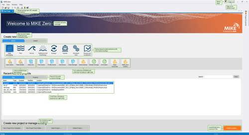
Access new tools, Cloud applications and an enhanced graphical overview from the redesigned MIKE Zero start page
MIKE Zero, DHI’s fully Windows integrated graphical user interface, is now better than ever and comes standard with all MIKE 21/3 software. Enjoy easy access to new MIKE Cloud applications and Cloud-enhanced functionality, plus an extended set of MIKE tools within theme-based (rather than product-based) interactive workflows. Ensure important model components such as sources and structures stay at the forefront with a new interactive, customisable floating mapping window. Lastly, the updated tabbing functionality will help you work in a more organised and efficient manner.
Let's get started
Learn how your project can benefit from long-term shoreline evolution modelling.
You may also like
Related technologies
LITPACK
Simulate littoral processes and coastline kinetics for effective coastal management.
MIKE 21-3 Mud Transport
Simulate fine-grained sediment transport to analyse siltation on marine, brackish, and freshwater projects.
MIKE 21-3 Sand Transport
Simulate the impact of sedimentation on ports, offshore energy, dredging, and coastal engineering.
How can we help?
With our global network of offices, we make sure you get the right answers to your local needs. Let us know what you're interested in (e.g., product features, trial license, pricing, etc.) and we will get back to you.
