
MIKE+ Model Manager
The core of the MIKE+ user interface
The Model Manager is the heart of MIKE+, acting as a centralized hub that links all MIKE+ applications and engines. Rely on its intuitive layout and workflows to tackle complex water system projects.
Designed to streamline the management, configuration, and presentation of your MIKE+ models, MIKE+ Model Manager includes an array of tools for result visualisation, graphical editing, and digital twin management. With built-in features to enhance performance and efficiency, you'll be modelling water distribution networks, collection systems, rivers, and flood scenarios in no time.
Other MIKE+ products
Interested in MIKE+ Model Manager?
Contact usHow does MIKE+ Model Manager help?
No in-house modellers?
Get our expert modellers on board for your consulting projects either as a partner, to provide extended user support, or for model and project reviews. Submit an inquiry
Additional capabilities & unique features
Explore our latest support resources, including guides, videos, and FAQs in our Knowledge Base.
What’s new in MIKE+ Model Manager - 2025
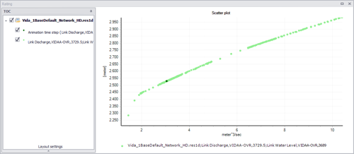
New Scatter Plot Window:
Analyse the relationship between any two result items or locations with the new scatter plot feature. Users can easily explore correlations, such as how water level changes in response to discharge at a selected location.
Plots Manager for result analysis:
The Plots Manager lets you save and organise result windows in a tree structure, enabling folder-based management. Users can reopen, duplicate, and edit plots without re-creating them, and reuse windows to compare results from alternative scenarios. Watch Video
Take advantage of additional features to manage your MIKE+ models and digital twins
- Use the Scenario Manager to define alternatives to a base scenario. Select which parameters are modified in the alternatives, and keep the others synchronised with the base scenario
- Import model data from various data sources, such as databases, shapefiles, Excel, etc
- Export selected model components to various file formats
- Export model components to ArcGIS Pro
- Use the Model Versioning management tool to efficiently keep models updated with changes in asset databases
- Verify and validate the output from various model versions using the built-in Result Differences tool
- Split and combine models in an easy manner
- Access spatial processing tools for model features, such as clipping, erasing, merging, etc.
- Simplify the model network through scrubbing, trimming and merging
- Integrate MIKE+ models with other applications including online and real-time control systems
Explore more built-in result presentation functionalities
- Create longitudinal profile plots from result maps
- Set up reports based on information from model data as well as simulation results
- Present a summary table of all calculated statistics, i.e. for all individual locations, variables and statistics types
- Create cross-section plots to display animated water level results from a network and/or 2D overland result files
- Present comparisons of model simulations and measured field data in maps, tables, or graphs
- Perform statistical analysis to determine the goodness of fit
Discover what else you do with MIKE+ ArcGIS Pro
- Pre-processing of GIS data before import to MIKE+
- Complex editing and data analysis requiring joining and relating several tables from various data sources
- Tasks involving complex spatial analysis and spatial joining of data
- Layouts, plot to scale and similar high-level reporting initiatives i.e. production of flood maps
- Geoprocessing tasks like intersecting, overlaying etc. apart from the predefined tasks existing in MIKE+
- CAD-style editing
- Share data and results to a wider group of user by publishing data and results to ArcGIS Online
Display BIM (Building Information Modelling) data in map view
MIKE+ also supports the seamless integration of BIM (Building Information Modelling) files into a map interface. This offers a more user-friendly and holistic approach to managing assets. From initial planning to ongoing operations, users can visualise assets in a whole new way. Plus, there’s potential for future applications in urban network management.
Save your results layout without needing to open a database
Maximise your productivity with this convenient feature that retains your results’ layout and symbology for future reference.
Let's get started
Learn how your project can benefit from this data management and presentation module.
Related technologies
MIKE+
Manage water systems with an integrated urban, river, and flood modelling platform.
MIKE+ 2D Overland
Predict flood impacts, identify risks, and propose effective mitigation measures.
MIKE+ Collection Systems
Accurately represent flow conditions and efficiently manage stormwater and wastewater.


How can we help?
With our global network of offices, we make sure you get the right answers to your local needs. Let us know what you're interested in (e.g., product features, trial license, pricing, etc.) and we will get back to you.